


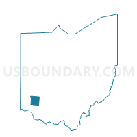
0144 SPG-C-NEA Voting District, Warren County, Ohio
About
Outline

Summary
| Unique Area Identifier | 653058 |
| Name | 0144 SPG-C-NEA Voting District |
| County | Warren County |
| State | Ohio |
| Area (square miles) | 0.28 |
| Land Area (square miles) | 0.28 |
| Water Area (square miles) | 0.00 |
| % of Land Area | 100.00 |
| % of Water Area | 0.00 |
| Latitude of the Internal Point | 39.58024780 |
| Longtitude of the Internal Point | -84.19929800 |
Maps


Graphs
Select a template below for downloading or customizing gragh for 0144 SPG-C-NEA Voting District, Warren County, Ohio


Neighbors
Neighoring Voting District (by Name) Neighboring Voting District on the Map
- 0033 CLC-T-EA Voting District, Warren County, OH
- 0092 SPG-C-EB Voting District, Warren County, OH
- 0154 SPG-C-NEB Voting District, Warren County, OH
- PRECINCT WASHINGTON-EE, Montgomery County, OH
Top 10 Neighboring County Subdivision (by Population) Neighboring County Subdivision on the Map
- Washington township, Montgomery County, OH (56,607)
- Clear Creek township, Warren County, OH (30,265)
Top 10 Neighboring Place (by Population) Neighboring Place on the Map
Top 10 Neighboring Unified School District (by Population) Neighboring Unified School District on the Map
- Centerville City School District, OH (56,638)
- Springboro Community City School District, OH (29,525)